Challenge. Perform characterization and analyses needed to obtain regulatory approval of alternate concentration limits (ACLs) and alternative abatement standards (AASs) for closure of a uranium mill site
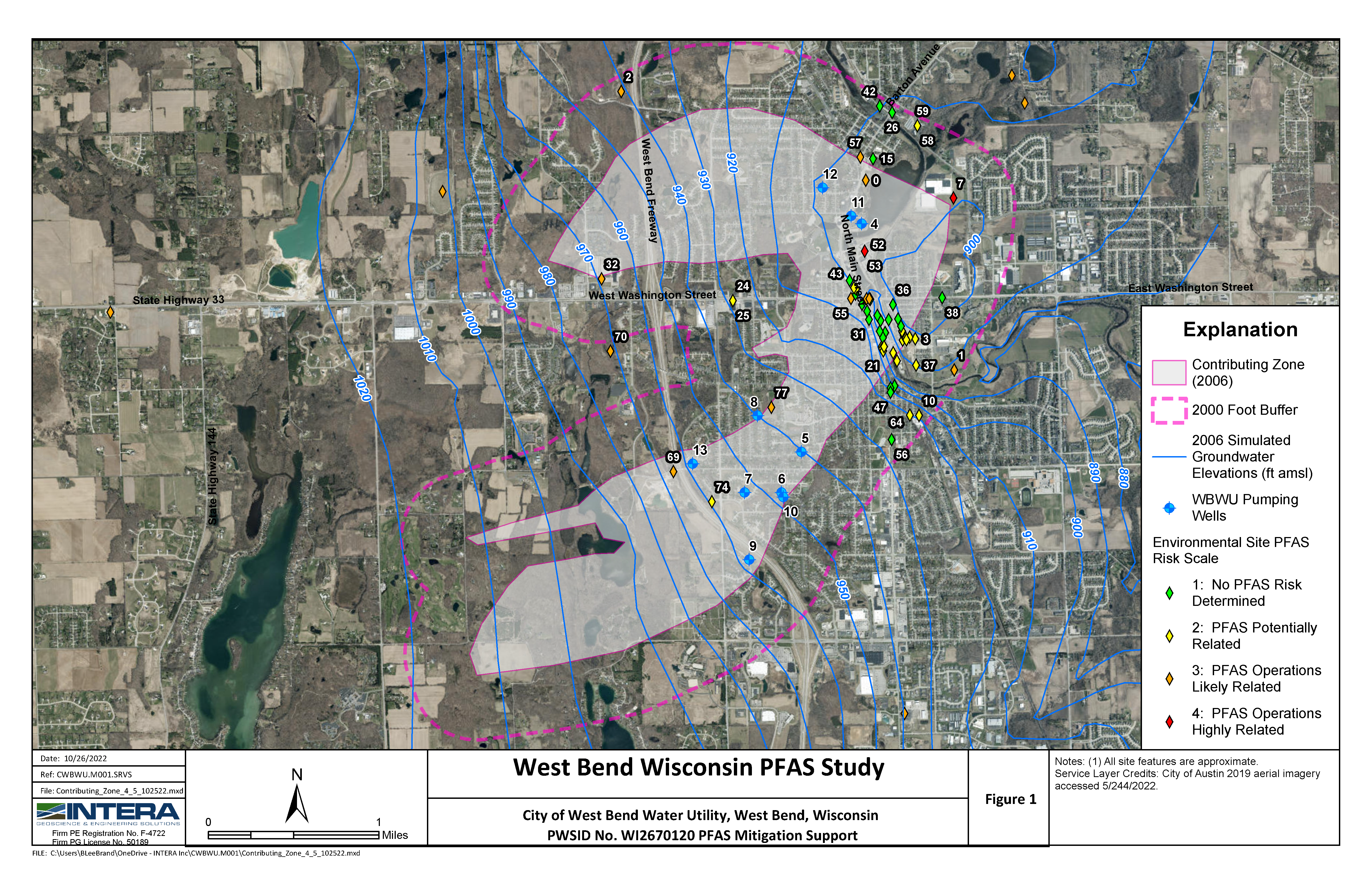
Solution. The Rio Algom Mine and Mill Site is located in the Ambrosia Lake Valley Sub-district of the Grants Uranium Mining District. Approximately 22 miles long, it is estimated that this mining district consists of hundreds of interconnected shafts and vents. INTERA staff conducted a hydrogeologic assessment of Rio Algom’s mine sites in the Ambrosia Lake area that included an evaluation of: an alluvial aquifer created as a result of mine dewatering activities, the manner in which alluvial waters may be connected to deeper aquifers, the water quality of deeper aquifers, and the nature and extent of constituents in excess of New Mexico Water Quality Control Commission standards. As a result of the hydrogeologic assessment and to support closure of the Quivera Mill, INTERA staff prepared an ACL application to the United States Nuclear Regulatory Commission (USNRC) for molybdenum, nickel, selenium, gross alpha, radium-226+228, thorium-230, natural uranium, and lead-210. The purpose of the ACL application was to replace the licensed maximum contaminant levels in groundwater with alternate levels that are still protective of human health and the environment while also being as low as reasonably achievable (ALARA). The ACL addressed source and contaminant characterization, contaminant transport, exposure assessment (both human health and ecological), assessment of the corrective action efforts, and an ALARA demonstration. Both groundwater and geochemical modeling were used in this effort. The ACL application was subsequently approved by the USNRC, thereby allowing discontinuation of the corrective action plan for groundwater. Additional activities include compiling regional hydrogeologic data, developing a conceptual hydrogeologic model, and developing and applying a 3-dimensional groundwater flow model. Results of our analyses have confirmed that a regional cone of depression that developed during the period of mine dewatering is still present in the area and will likely take hundreds of years to recover. Groundwater flow directions in response to this cone of depression are towards the center of the valley and away from existing receptors. Since some constituents of concern in groundwater naturally exceed standards, particularly in the alluvial and ore-bearing aquifers, natural attenuation mechanisms are active, and negative impacts to water resources being used in the area are unlikely, the closure strategy includes receiving approval for AASs from the New Mexico Water Quality Control Commission to close the site with the State of New Mexico.