Challenge. Evaluate trends in agricultural irrigation to understand how agricultural water use and associated evaporative losses have changed over the last 20 years in a large river basin
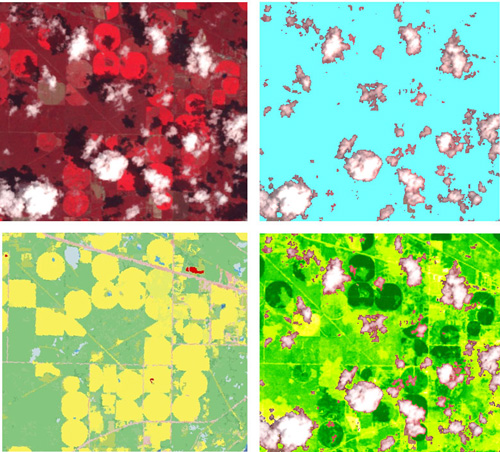
Solution. To facilitate the quantification of irrigation changes in the Apalachicola, Chattahoochee, and Flint (ACF) River Basin, a basin where intermittent records had been maintained, INTERA used Landsat satellite data to develop a continuous data record by calculating average surface temperature and the Normalized Difference Vegetation Index (NDVI) as indicators of consumptive water use and crop yield, respectively. Surface temperature data was used as a proxy for relative water use between agricultural areas and grasslands over time due to the greater cooling effect of evaporation augmented by irrigation water. NDVI compares how visible and infrared light is reflected by plants, as plants with larger and healthier biomass absorb more visible light for photosynthesis and chlorophyll reflects infrared radiation. We used NDVI to evaluate biomass associated with different land uses and quantify the impact of irrigation on crops. One of the limitations of the use of Landsat data was the presence of clouds that can completely or partially obstruct land cover features on portions of the Landsat scenes. To solve the cloud data coverage issue, INTERA analyzed all existing Landsat data in the period of study and filtered out pixels identified as having clouds using an empirical algorithm based on brightness temperature and known band spectral indices that discriminate clouds. Once the pixels with clouds for each date were identified, different aggregation methods were used to obtain average surface temperate and NDVI for each date with available Landsat data and to examine relative changes overtime. The results of our analysis have greatly improved the understanding of how agricultural water use has changed in the ACF River Basin over the last 20 years.