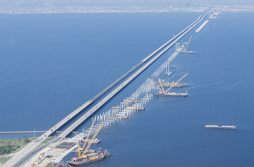
Challenge. Provide the Louisiana Department of Transportation and Development (LADOTD) with planning tools to support the design and assessment of coastal bridges and roadways
Solution. Bridges and roadways in the low-lying coastal areas of Louisiana are vulnerable to the elevated water levels, high velocity flows, and wave conditions that accompany tropical storms and hurricanes. INTERA performed an AASHTO Level III wave/storm surge vulnerability analysis to develop the 100-year design met/ocean conditions for all coastal regions of Louisiana. The results provided the input to develop a GIS database, in the form of a wave and storm surge atlas that identifies LADOTD bridges and roadways vulnerable to this type of loading. INTERA simulated 150 tropical storms and hurricanes (including historical and synthetic storms) with the fully-coupled SWAN+ADCIRC model and performed an extreme value analysis on water levels and waves to derive the corresponding 100-year conditions. Surge/wave forces and moments on the superstructures of the coastal bridges, along with their resistive forces and moments (based on the span dead weight) on one or more spans, determined the vulnerability of each bridge. In addition to the 100-year wave and storm surge atlas, INTERA developed 5-, 10-, 25-, and 50-year atlases to provide designers with flexibility for the design of temporary facilities (e.g., detour bridges) and retrofitting existing bridges. The wave and storm surge atlases are serving as valuable planning tools for the LADOTD in designing new coastal transportation infrastructure as well as retrofitting existing bridges and roadways.