Challenge. Develop long-term water planning and management tools for use by state agencies, groundwater conservation districts, regional water planning groups, and other interested stakeholders.
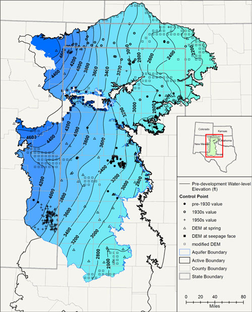
Solution. INTERA has led the development of over a dozen regional-scale groundwater availability models (GAMs) of aquifers across Texas under the Texas Water Development Board’s Groundwater Availability Modeling Program. Once developed, these MODFLOW models serve as tools for evaluating water management strategies and assessing potential impacts of regional water plans over a 50-year planning horizon. Work on each of these models involves data collection and analysis related to aquifer geometry, properties, water quality, recharge, and surface/groundwater interaction; development, calibration, and application of groundwater flow models; evaluation and modeling of surface water/groundwater interaction; GIS data development and presentation; geology and model visualization; reporting and web publishing; and the organization and execution of quarterly stakeholder meetings to present project status to state, regional, and local water resource planners. Major Texas aquifers that we have developed GAMs for include the Carrizo-Wilcox, Northern Trinity, Seymour, and Ogallala (as part of the High Plains Aquifer System GAM). For minor aquifers, we have developed models of the Queen City, Sparta, Dockum, Rustler, Yegua-Jackson, Woodbine, Edwards- Trinity and Rita Blanca (included in the High Plains Aquifer System GAM), and Brazos River Alluvium. INTERA’s modeling expertise and proven ability to deliver high-quality models on-time and on-budget has resulted in the TWDB selecting us to develop more GAMs than any other contractor.