Challenge. Analyze and assimilate wind/storm surge data and provide tool to support resolving insurance claims resulting from flooding and wave damage.
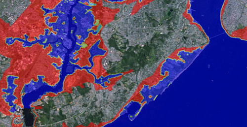
Solution. For a major insurance company, INTERA provided a hindcast of the winds, storm surge elevations, wave heights, and flow velocities experienced during Hurricane Sandy (2012) throughout coastal New York, New Jersey, and Connecticut. INTERA’s hydrodynamic and wave analysis approach involved applying the fully-coupled SWAN+ADCIRC model. We acquired the FEMA Region 2 calibrated model mesh, which substantially reduced the time required for model development when compared to developing a new model. As a quality control measure, we validated the FEMA model mesh node elevations with other publically available elevation data to ensure accurate representation of regional topography and bathymetry. The FEMA model meshes are extremely detailed, providing resolution of several meters for mesh elements in refined areas. While this level of resolution allows extraction of values at individual properties, it also requires extensive computational resources. To address this, we used the University of Florida Center for High Performance Computing’s 16,000+ processor system to run model simulations. The model results were validated with publically-available measured data extracted from NOAA tidal stations, USGS stream gages, National Data Buoy Center wave buoys, as well as high-water marks collected by USGS and FEMA. INTERA delivered the simulation results in a portable ArcGIS application, accessible from the free ESRI ArcGIS viewer. The ArcGIS database contained detailed information on maximum surge level, wind speed and direction, flow velocity, and wave height. To assist the field engineers in establishing a timeline of effects at each desired location, associated values of each parameter at the time of the maximum of all other parameters appeared as separate datasets in the database. INTERA concurrently developed aerial image map coverage and USGS topographic map coverage during the modeling phase of the project. We also conducted a training seminar for the database end-users covering product installation, ArcGIS viewer use, and data interpretation.