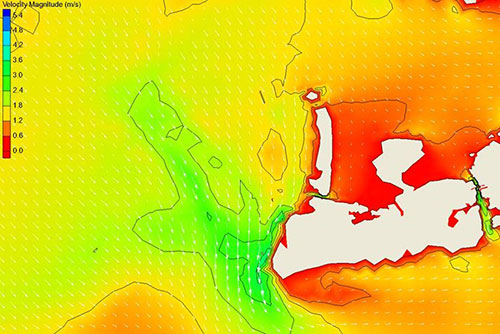
Challenge. Analyze sediment transport and shoaling to support development of a long-term dredging maintenance plan.
Solution. INTERA simulated historical storm events to compute hydrodynamic conditions in and near the federal navigation channel at Key West in support of the modeling of channel sedimentation rates. The project included a comprehensive data/information search and compilation, a field measurement program to provide calibration data for the modeling, acquisition of meteorological data for 40 storms that have affected the area, hindcasting of historical storms, and statistical analyses of the data produced by the model runs. INTERA worked closely with USACE to provide hydraulic conditions to perform sediment transport modeling and evaluate shoaling within the channel. The results supported development of a long term dredging maintenance plan to address storm-generated shoaling and identify disposal management alternatives.