INTERA
  • Services and Industries
    • Services
      • Water Resources and Supply
      • Environmental
        • Air Quality
      • Coastal Engineering
      • Radioactive Waste
    • Specialty Services
      • Climate Resiliency
      • Uncertainty Analysis
      • Emerging Contaminants (PFAS)
      • Digital Transformation
      • Carbon Storage
    • Industries
      • Mining
      • Water Utilities
      • Oil and Gas
      • Legal
      • Power and Energy
      • Government
      • Brownfields
      • Solid Waste
      • Semiconductor
  • Projects
  • Company
    • About INTERA
    • Purpose, Promise, and Values
    • Leadership
    • Careers
    • Locations
    • Media
  • EN
    • ES (Spanish)
    • FR (French)
    • DE (German)
INTERA

INTERA

Environmental and Water Resource Consulting Firm

  • Services and Industries
        • Services
          • Water Resources and Supply
          • Environmental
            • Air Quality
          • Coastal Engineering
          • Radioactive Waste
        • Specialty Services
          • Climate Resiliency
          • Uncertainty Analysis
          • Emerging Contaminants (PFAS)
          • Digital Transformation
          • Carbon Storage
        • Industries
          • Mining
          • Water Utilities
          • Oil and Gas
          • Legal
          • Power and Energy
          • Government
          • Brownfields
          • Solid Waste
          • Semiconductor
  • Projects
  • Company
    • About INTERA
    • Purpose, Promise, and Values
    • Leadership
    • Careers
    • Locations
    • Media
  • EN
    • ES (Spanish)
    • FR (French)
    • DE (German)

Coastal Engineering

March 2, 2022 · (Updated: July 18, 2022)

March 2, 2022 by

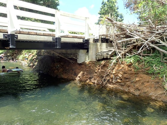
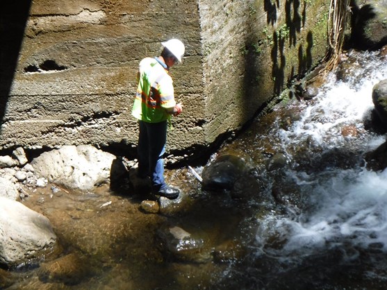
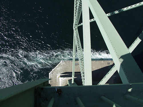
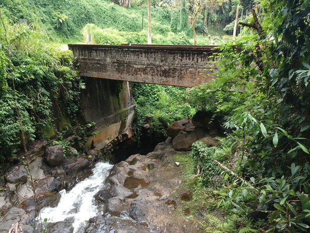
Challenge: To evaluate the safety of bridges throughout the state of Hawaii 

Solution: Since 2021, INTERA has participated as part of an engineering team responsible for conducting a phased evaluation of the scour vulnerability of bridges across the state of Hawaii. To date, the evaluations have assessed the foundations of 314 bridges, and have included site visits, hydraulic modeling, scour calculations, stability analyses, and developing plans-of-action for bridges determined to be vulnerable. INTERA has completed evaluations of 120 bridges on Oahu and the Big Island. The project is ongoing as recommendations have been made for further evaluations of 98 of the bridge structures

Results: As a result of our preliminary evaluations, INTERA has recommended that 98 of the 120 bridge structures be further examined to help ensure public safety.

Continue Reading
August 30, 2015 · (Updated: July 18, 2022)

August 30, 2015 by

Project-SR-A1A---Before
Project-SR-A1A---After

Challenge. Quantify potential erosion and toe scour to aid in fast-track design of seawall proposed in response to erosion caused by Hurricane Sandy and the Thanksgiving Day storm

Solution. In fall 2012, Hurricane Sandy undermined sidewalks, an existing decorative wall along State Road A1A, and portions of the roadway. To support the installation of an emergency steel sheet pile seawall along this damaged section of roadway, INTERA quantified potential beach erosion and toe scour during storm events to aid in design of the proposed seawall. We also examined beach fill alternatives to quantify benefits and the reduction of scour at the wall. INTERA examined historical shoreline behavior; developed representative beach profiles; applied the United States Army Corps of Engineers (USACE) cross-shore erosion model, SBEACH, to evaluate storm-induced scour for 10-, 20-, 50-, and 100-year storms; and determined local scour at the seawall for selected wall design lives. Concurrently, INTERA examined minimum (defined by permitting agencies) and desired (defined by client) beach fill templates to quantify their effects on reducing scour at the seawall to support environmental permitting. Qualitative analyses included beneficial effects of beach fill on reducing wave damage potential to upland infrastructure and possible detrimental effects of no beach fill on fronting and adjacent beaches. We also delineated a potential upland source of beach fill material. The permitting agencies approved our analyses without revision.

Continue Reading
August 26, 2015 · (Updated: July 18, 2022)

August 26, 2015 by

Project-Hurricane-Sandy-Hindcast

Challenge. Analyze and assimilate wind/storm surge data and provide tool to support resolving insurance claims resulting from flooding and wave damage.

Solution. For a major insurance company, INTERA provided a hindcast of the winds, storm surge elevations, wave heights, and flow velocities experienced during Hurricane Sandy (2012) throughout coastal New York, New Jersey, and Connecticut. INTERA’s hydrodynamic and wave analysis approach involved applying the fully-coupled SWAN+ADCIRC model. We acquired the FEMA Region 2 calibrated model mesh, which substantially reduced the time required for model development when compared to developing a new model. As a quality control measure, we validated the FEMA model mesh node elevations with other publically available elevation data to ensure accurate representation of regional topography and bathymetry. The FEMA model meshes are extremely detailed, providing resolution of several meters for mesh elements in refined areas. While this level of resolution allows extraction of values at individual properties, it also requires extensive computational resources. To address this, we used the University of Florida Center for High Performance Computing’s 16,000+ processor system to run model simulations. The model results were validated with publically-available measured data extracted from NOAA tidal stations, USGS stream gages, National Data Buoy Center wave buoys, as well as high-water marks collected by USGS and FEMA. INTERA delivered the simulation results in a portable ArcGIS application, accessible from the free ESRI ArcGIS viewer. The ArcGIS database contained detailed information on maximum surge level, wind speed and direction, flow velocity, and wave height. To assist the field engineers in establishing a timeline of effects at each desired location, associated values of each parameter at the time of the maximum of all other parameters appeared as separate datasets in the database. INTERA concurrently developed aerial image map coverage and USGS topographic map coverage during the modeling phase of the project. We also conducted a training seminar for the database end-users covering product installation, ArcGIS viewer use, and data interpretation.

Continue Reading
August 3, 2015 · (Updated: July 19, 2022)

August 3, 2015 by

Project-Tacoma-Narrows-Bridge

Challenge. Estimate design scour at existing and proposed bridge piers under large, tidal-influenced flow conditions and deep water depths

Solution. INTERA performed hydraulic and scour analyses for the existing and proposed Tacoma Narrows Bridge piers. This site experiences large astronomical spring tides and tidal induced flow velocities. Additionally, the water depths range from 120 feet at the channel piers to greater than 250 feet in the center of the channel. Both existing and proposed piers are large, rectangular in shape, and skewed to the flow. These conditions, combined with the fine sand bed materials made for a challenging scour analysis. INTERA configured a 2-dimensional, depth averaged computer model (RMA-2 model) for the tidal waters encompassing the bridge site, and extending from Puget Sound to Olympia, Washington. The model calibration data included measured water elevation, velocity, and discharge data at and near the bridge site. The model simulated flow conditions for spring tides as well as for the 100-year, and 500-year return interval design conditions. To address the close proximity of the new and existing piers, INTERA designed, conducted, and analyzed physical model local scour tests.

Continue Reading
August 3, 2015 · (Updated: July 19, 2022)

August 3, 2015 by

Project-Chicago-Morgan-Shoal

Challenge. Design shoreline structures to meet the level of protection specified by the National Economic Development (NED) plan

Solution. Taking advantage of a large bedrock outcropping (Morgan Shoal) that lies just offshore, the City of Chicago and Chicago Department of Transportation considered an alternative shoreline protection scheme—a series of offshore breakwaters/islands to support ecological functions/habitat in their lee—in lieu of the NED plan’s rubblemound revetment along the 45th Street to 51st Street segment of this federal shore protection project. INTERA defined the appropriate wave climate near the project by employing the United States Army Corps of Engineers’ (USACE) Coastal Modeling System wave model (CMS-Wave) to transform waves from the offshore Wave Information Study station to the site and examined breakwater/island configurations and substrate stability in their lees via empirical formulas and desktop assessment tools. During the course of the design process, the public wanted to preserve the shoal and suggested a scaled back shoreline alternative. The reduced conceptual plan consisted of an onshore rubblemound revetment with an amphitheater area (comprising special placement of cut stone) and a small pebble beach, to mimic the existing pebble beach, in front of the amphitheater toe. INTERA developed typical sections of the rubblemound revetment including areas where the shoreline extended into the lake beyond the existing shoreline and the amphitheater area. We also participated in a meeting with the USACE Chicago District to ensure the design met federal and NED standards.

Continue Reading
August 3, 2015 · (Updated: July 19, 2022)

August 3, 2015 by

Challenge. Determine appropriate repairs or replacement of articulated concrete block (ACB) mattress installed to protect nearly 14 miles of roadway and embankment

Solution. County Road 707 along the Indian River experienced major damage during the 2004 hurricane season. Subsequent emergency repairs to the roadway and its embankment included installing ACB mattress. Storm events in 2005 caused considerable damage to portions of the repaired shoreline. INTERA assessed the condition of the existing ACB, modeled wave conditions at the site, and developed appropriate alternatives for repair or replacement of the ACB. Our engineering evaluation revealed that the damaged ACB mattress revetment could only withstand conditions corresponding to an approximately three-year return period event. Given these facts, INTERA developed three conceptual alternative designs. Alternatives considered removal of the existing revetment. Since this would have required significant costs and further disturbed this environmentally sensitive area, the desired alternative incorporated the existing protection and provided for offshore wave attenuation via mangrove plantings. This alternative had the advantage of a low cost, the environmental benefits associated with a mangrove forest, incorporating the existing revetment, and not interfering with any protection installed by homeowners because it sat below mean high water.

Continue Reading
  • Go to page 1
  • Go to page 2
  • Go to page 3
  • Go to Next Page »

Footer

Contact Us

INTERA, HQ
9600 Great Hills Trail
Suite 300W
Austin, TX 78759
+1 (512) 425-2000

Learn More

  • Blog
  • News
  • Events
  • Permits

Information

  • Terms and Conditions
  • Privacy Policy
  • Sitemap
  • LinkedIn
  • Twitter

Get the latest!

I am interested in receiving news and thought leadership content from INTERA.

  • This field is for validation purposes and should be left unchanged.

© INTERA 2022 Developed by Gloss