Challenge. Apply remote sensing to evaluate potential reductions in water consumption from converting traditional flood irrigation to drip irrigation
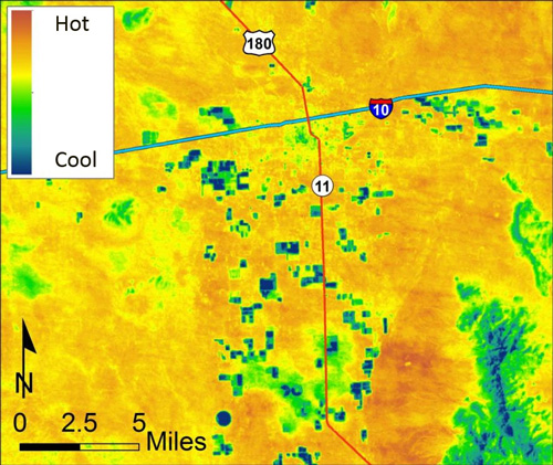
Solution. As water supply shortages continue to increase, water management agencies are compelled to evaluate the impacts of agricultural irrigation on economic development and sustainability. One of the strategies used to reduce such impacts is the conversion of traditional irrigation methods to more water-efficient practices. As part of a larger effort by the New Mexico Interstate Stream Commission to understand the environmental and economic impact of converting from flood irrigation to drip irrigation, INTERA evaluated the water-saving effectiveness of drip irrigation in the Deming, New Mexico area using a remote-sensing-based technique combined with ground data collection. The remote-sensing-based technique used relative temperature differences as a proxy for water use to show relative differences in crop consumptive use between flood- and drip-irrigated fields. Temperature analysis showed that, on average, drip-irrigated fields were cooler than flood-irrigated fields, indicating higher water use. The higher consumption of water by drip-irrigated fields was supported by a determination of evapotranspiration (ET) from all fields using the Mapping Evapotranspiration with Internalized Calibration (METRIC™) Landsat-based surface energy balance model. METRIC analysis yielded higher instantaneous ET for drip-irrigated fields when compared to flood-irrigated fields and confirmed that drip-irrigated fields consumed more water than flood-irrigated fields planted with the same crop. More water use generally results in more biomass and hence higher crop yield, and this too was confirmed by greater relative Normalized Difference Vegetation Index for the drip irrigated fields. Results of INTERA’s work confirm previous estimates regarding the impacts of increased efficiency of drip irrigation on higher water consumption in the area. The higher water consumption occurs with drip because, with the limited water supplies and regulated maximum limits on pumping amounts, the higher efficiency of drip enables producers to convert larger percentages of pumped groundwater into ET and reduces the 'return' of percolation 'losses' back to the groundwater system that previously re-recharged the aquifer. Our analysis illustrates the usefulness of remote sensing techniques to evaluate spatial patterns of ET by different irrigation methods. The results illustrate a first-step quantitative tool that can be used by water resource managers in formulation of policy to limit net water consumption and maintain reliable water supply sources.