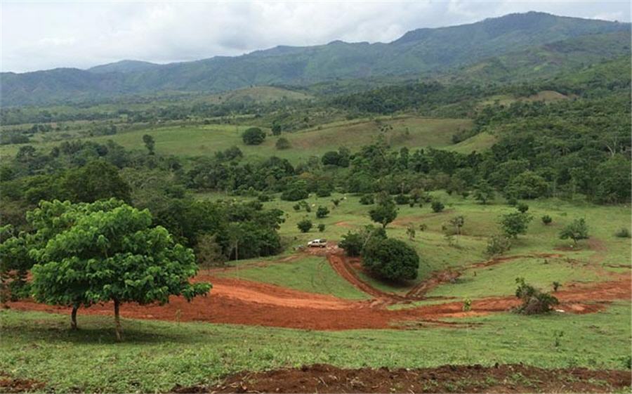
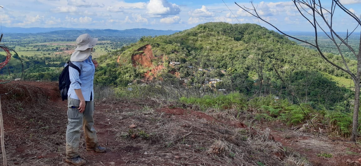
INTERA
  • Services and Industries
    • Services
      • Water Resources and Supply
      • Environmental
      • Coastal Engineering
      • Radioactive Waste
    • Specialty Services
      • Carbon Storage
      • Uncertainty Analysis
      • Air Quality
      • Digital Transformation
    • Industries
      • Mining
      • Water Utilities
      • Oil and Gas
      • Legal
      • Power and Energy
      • Government
      • Brownfields
      • Solid Waste
      • Semiconductor
  • Projects
  • Company
    • About INTERA
    • Purpose, Promise, and Values
    • Leadership
    • Careers
    • Locations
    • Media
  • EN
    • ES (Spanish)
    • FR (French)
    • DE (German)
INTERA

INTERA

Environmental and Water Resource Consulting Firm

  • Services and Industries
        • Services
          • Water Resources and Supply
          • Environmental
          • Coastal Engineering
          • Radioactive Waste
        • Specialty Services
          • Carbon Storage
          • Uncertainty Analysis
          • Air Quality
          • Digital Transformation
        • Industries
          • Mining
          • Water Utilities
          • Oil and Gas
          • Legal
          • Power and Energy
          • Government
          • Brownfields
          • Solid Waste
          • Semiconductor
  • Projects
  • Company
    • About INTERA
    • Purpose, Promise, and Values
    • Leadership
    • Careers
    • Locations
    • Media
  • EN
    • ES (Spanish)
    • FR (French)
    • DE (German)

Mining

July 26, 2022 · (Updated: August 8, 2022)

July 26, 2022 by

Challenge: To establish baseline geochemistry and hydrogeology in support of a Preliminary Feasibility Study (PFS) and Environmental Impact Assessment (EIA) for a remote site with limited access.

Solution: INTERA completed a PFS-level baseline environmental and hydrogeological investigation for the San Matias Copper-Silver-Gold Project (San Matias) in northwest Colombia.  In collaboration with a local consulting partner, INTERA developed and performed a baseline investigation of site hydrogeology, hydrology, and mine-waste geochemistry designed to meet industry best practices and the requirements for a Colombian EIA. This work included characterization of the surface water (flow and chemistry) within the regulatory required hydrologic “area of influence”, as well as for the San Pedro River basin to inform the water supply trade off study.  To inform the surface and groundwater water balances as well as the numerical groundwater modeling, we conducted geophysical surveys, performed spring and water usage census; installed piezometers, and designed, installed and operated surface water flow measurements networks.  The aquifer testing program required a creative approach that integrated packer, injection, slug, and pumping tests due to limited access. Five of the electrical resistivity tomography lines for groundwater characterization were performed using pack animals in one area of the site and other wells required access by horseback. A geochemical characterization program that included standard static and kinetic testing was developed and implemented for the proposed waste rock, tailings, and condemnation area soils. The geochemical program also included a characterization of the geochemical properties, metal content and extent/volume of artisanal tailings deposited in streams for an evaluation of remedial options. Data from the hydrogeologic program were used to develop conceptual and numerical models of groundwater flow for a preliminary evaluation of mine pit inflows and the impacts of river withdrawals. 

Results: Data and analyses from the investigations were consolidated into a NI 43-101 Pre-Feasibility Study Technical report that will inform the upcoming Environmental Impact Assessment for the national regulatory agency (ANLA).  

Continue Reading
July 26, 2022 · (Updated: August 2, 2022)

July 26, 2022 by

Challenge: To quantify expected groundwater inflows and evaluate acid generating or neutralizing potential of subsurface material in support of the mine permitting process.  

Solution: Resolution Copper is a proposed underground copper mine with the target porphyry deposit between 4,500 and 7,000 feet below ground surface. The deposit will be mined using panel caving techniques. Groundwater inflows to the shafts during construction and into the workings during operations was expected. Geologic and hydrogeologic modeling was necessary to advance the project during the feasibility investigations and Arizona Aquifer Protection Permit (APP) process. Geochemical investigations of acid generating or neutralizing potential of subsurface material were also needed to support Resolution’s permitting process for the Environmental Impact Statement (EIS) and the APP. In addition, the panel caving mining technique will result in a subsidence zone above the mine area, Surface subsidence and fracturing will lead to additional water flowing into the mine. Resolution Copper mine operators need to develop reliable predictions for future inflows into the mine as well as the potential for the subsurface material to generate acidic waste. INTERA developed regional-scale and mine-scale geologic block models using Leapfrog Geo and a regional model  combining separate sub-regional models created using the Leapfrog and Vulcan software programs. Both the regional and mine-scale models were developed as a basis for further groundwater flow modeling in support of mine permitting. Using MODFLOW-SURFACT, INTERA modeled groundwater inflows to two shafts excavated into the graben encompassing the mine. Inflows to the shaft were used to calibrate hydraulic parameters, especially for the deep geologic units. Prediction of inflow rates area essential for mine planning as well as providing water balance estimates for use in groundwater impact analyses. We also developed an update to the conceptual model of groundwater flow and occurrence in the Apache Leap Tuff to determine the potential flow of groundwater from this unit into the mine during subsidence. In addition to the geologic and groundwater flow modeling, INTERA evaluated the subsurface material to determine the acid generating or neutralizing potential of the material, as well as its ability to leach metals. INTERA collected, compiled, and documented geochemical test data to determine the source and potential mitigation of elevated selenium concentrations in the ore and to more realistically predict mercury concentrations expected during weathering of waste rock. 

Results: INTERA’s groundwater modeling and geochemical evaluations supported the successful publishing of the Final EIS for the mine.

Continue Reading
July 18, 2022

July 18, 2022 by

Challenge: To help select and permit an optimal mine closure strategy.

Solution: INTERA developed a groundwater flow and transport model of the Maurliden mining area to simulate the potential impacts of various mine closure options on water resources. This work was completed in support of a Pre-Feasibility Study and environmental permit application required for mine closure. The Maurliden mining area consists of polymetallic (Zn-Pb-Cu-Au-Ag), open-pit mines. Each volcanic-hosted massive sulfide deposit consists of a fractured rhyolite bedrock system overlain by approximately 10 meters of relatively more permeable glacial till. Dissolved metals are generated by the natural oxidation of highly sulfidic (~20 weight % sulfide) materials present in the waste rock dump and in the wall rock of the open pit, and these represent the two principal sources of constituents of potential concern that could impact ground and surface water through various pathways. In support of selecting the best closure strategy for the Maurliden Mine, a calibrated groundwater flow and transport model was developed and applied to predict future concentrations of dissolved metals in nearby groundwater and surface water resources over a 1,000-year period. In developing the conceptual and numerical models, INTERA characterized the hydraulic properties of the predominately fractured bedrock system through a field program that included flow logging, single-well pumping tests, and a multiple-well pumping test. Following the interpretation of flow logging and pumping tests, and after model calibration, the model was used to evaluate nine different closure options with two future climate scenarios for three constituents of potential concern. Closure options ranged from capping the waste rock dump in place and allowing the natural formation of a pit-lake, to completely filling the open pit with cemented paste backfill mixed with offsite tailings.  

Results: The modeling simulations informed Boliden’s decision on the best closure strategy to be presented in an environmental permit application to the Swedish Land and Environmental Court. 

Continue Reading
April 15, 2022 · (Updated: March 8, 2023)

April 15, 2022 by

Challenge: To store tailings produced by reprocessing gold leaching piles in a cost-effective manner that is protective of the environment. 

Solution: We determined that the safest and most economical solution for storing the tailings was to place them in one of the inactive mine pits. To accomplish this, INTERA characterized the hydrogeology of the pit and the geochemistry of the tailings and potentially reactive surfaces of the pit. These efforts supported the preparation and submittal of a successful permit application to the SEMARNAT for the in-pit disposal of tailings from reprocessed ore . A hydraulic testing program was conducted to characterize the andesite aquifer adjacent to the candidate pit. The program consisted of drilling five deep core holes (approximately 200 meters each) to identify fractures that could conduct groundwater, performing packer tests, and installing vibrating wire piezometers. To achieve a better understanding of groundwater flow, we also collected hydraulic field data, performed a water balance for the pit, and oversaw the development of a hydrogeological conceptual model of regional and local groundwater flow systems. The geochemistry program included static geochemical analyses of tailings and pit surfaces, and a hydrochemical assessment of seeps in the pit. 

Results: Our hydrogeological and geochemical evaluations showed that most of the groundwater flow is through fractures under the pit, the tailings have no potential for acid generation, and that the contrast between the hydrogeological characteristics of the tailings and the fractured rock will minimize the inflow of groundwater and the outflow of tailings solutions during their consolidation. The permit for in-pit tailings storage obtained from the SERMANAT was the first of its kind issued in Mexico. 

Continue Reading
October 1, 2021 · (Updated: August 2, 2022)

October 1, 2021 by

Challenge: Develop a 2.2 million gallon per day water supply for a fast-tracked $100 million proppant mine in Texas 

Solution: A reliable and sustainable water supply is critical to the success of proppant mining operations. In support of this $100 million, fast-tracked project (completed in less than six months) to develop two new proppant mines in west Texas, INTERA evaluated and developed groundwater supplies capable of delivering 2.2 mgd. We performed a groundwater availability analysis based on available geophysical logs and reports, designed an exploratory test program, and then located and supervised the installation and testing of production wells. At both mine sites, 15 production wells were installed. Using results from aquifer step-drawdown tests, INTERA sized the individual pumps for each well. We also developed a groundwater model to evaluate the long-term sustainability of the groundwater resource for different future conditions and to design the transmission system from the well field to a central storage tank. 

Continue Reading
September 2, 2015 · (Updated: August 2, 2022)

September 2, 2015 by

Challenge. To identify, develop, and permit a 4,000-gpm (252 L/s) water supply and to manage the environmental permitting process for a proposed mine and mill in a region where freshwater resources are both scarce and the focus of public and regulatory concern.

Solution. INTERA led a program of exploratory drilling, aquifer testing, and groundwater flow modeling, to demonstrate that the deep, non-potable Capitan aquifer can sustain the proposed pumping rate of 4,000-gpm (252 L/s) for the 50-year life of the mine. We designed and drilled two production wells, each approximately 5,387-ft (1,642-m) deep, and characterized aquifer properties by conducting a 7-day, constant-rate pumping test. Water produced from testing was stored in a 7M gallon (26M L) storage pond engineered, constructed, and reclaimed by INTERA. As required by the federal Environmental Impact Statement (EIS) process, a groundwater model was developed to evaluate the impacts of proposed pumping on the Pecos River, a connected stream subject to an Interstate Compact Agreement for water deliveries between the states of New Mexico and Texas. The model results showed minimal impacts from pumping to the Pecos River and government approvals of the model were delivered without delay to the 28-month EIS process. In support of the Owner’s disclosure requirements, INTERA contributed to the NI 43-101-compliant Preliminary Economic Assessment, Pre-Feasibility Study, and Feasibility Study by authoring the water availability and environmental permitting sections. Environmental permitting responsibilities included managing the EIS contractor, securing the air quality permit for construction, and managing specialty environmental surveys. Additional details on the project can be found here.

Continue Reading
  • Go to page 1
  • Go to page 2
  • Go to page 3
  • Go to Next Page »

Footer

Contact Us

INTERA, HQ
9600 Great Hills Trail
Suite 300W
Austin, TX 78759
+1 (512) 425-2000

Learn More

  • Blog
  • News
  • Events
  • Permits

Information

  • Terms and Conditions
  • Privacy Policy
  • Sitemap
  • LinkedIn
  • Twitter

Get the latest!

I am interested in receiving news and thought leadership content from INTERA.

  • This field is for validation purposes and should be left unchanged.

© INTERA 2022 Developed by Gloss